


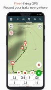


SityTrail hiking trail GPS
SityTrail hiking trail GPS leírása
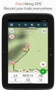
Menjen, és fedezze fel a világ összes ösvényét
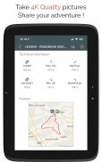
• Rögzítse nyomvonalait, miközben HD és földrajzi címkével ellátott képeket készít kalandjairól.
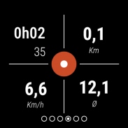
• Megtett távolság, Km-erőfeszítés, átlagsebesség, elégetett kalória stb.
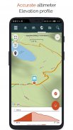
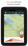
• Pontos magasságmérő, magasságkülönbségek számítása és magassági profil, amely megjeleníti az aktuális tartózkodási helyét.
• Riasztás, ha letér a követett nyom útvonaláról. Többé nem kell visszalépni!
• Az érdekes helyek automatikus aktiválása szövegfelolvasó funkcióval.
• Hozzon létre egy ingyenes fiókot, és minden adata minden eszközön elérhető lesz.
• Könnyű ösvények és látnivalók létrehozása weboldalunkról.
• Online szerkesztőnkkel PC/Mac számítógépén webböngészővel hozhatja létre saját nyomvonalait, majd közvetlenül okostelefonjáról érheti el, hogy megtapasztalhassa őket a földön.
• Rendezze és osztályozza útvonalait és látnivalóit saját listáiban.
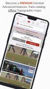
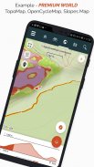
Legyen tovább, és legyen PREMIUM felhasználó!
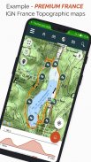
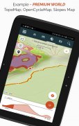
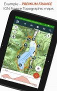
• Töltse le a világ topográfiai térképeit offline használatra.
• Fedezze fel a GR túraútvonalakat, európai túraútvonalakat, Santiago de Compostela zarándokútjait stb.
• Adjon hozzá tetszőleges topográfiai térképeket az IGN Franciaországtól, IGN / NGI Belgiumtól, IGN Spanyolországtól, swisstopotól, Ausztriától, USA-tól (USGS topográfiai térképezés), Kanadától (Toporama).
• Felfedezheti az összes kerékpáros hálózatot is: Greenway hálózat Franciaországban, Ravel Belgiumban, európai kerékpárútvonalak, csomópontok hálózatai Flandriában és Hollandiában.
• Télen pedig fedezze fel az összes sípályát a nevükkel együtt.
• Hozzáférés a SityTrail tagok és közösségek ösvényeinek nyilvános katalógusához.
• Speciális nyomkövetési és irányítási funkciók a hátralévő távolság és idő kiszámításával, valamint hangutasításokkal a kereszteződésekben.
• Menjen tovább, és alakítsa át kedvenc ösvényeit valódi multimédiás útmutatókká szöveggel, fotókkal, videólinkekkel, és ossza meg őket a SityTrail közösséggel.
• Hozzon létre saját túrázó közösségeket, és kezelje tagjait és hírfolyamait.
• Hozzon létre nyomvonalakat speciális funkcióinkkal a nyomvonal szerkesztéséhez weboldalunkon keresztül.
• Nyomtatási útvonalak PDF formátumban QR kódokkal. (A4, A3).
• Hozzáférés a földrajzi címkével ellátott Wikipédia cikkekhez a SityTrip modulunkból.
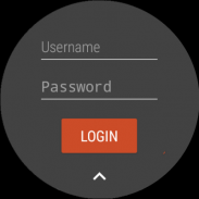
Rögzítsen nyomvonalat Wear OS óráján
Rögzíthet nyomvonalat Wear OS óráján önálló módban (nem csatlakozik Android okostelefonhoz) vagy párosított módban (Android okostelefonhoz csatlakoztatva).
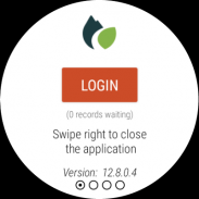
Az alkalmazás azt is lehetővé teszi, hogy bejelentkezzen a meglévő SityTrail fiókjába (a bal oldali képernyőről), ha az órát önálló módban használja.
Fontos információk
• Egyes funkciókhoz internetkapcsolat szükséges.
• A GPS hosszan tartó használata csökkentheti az akkumulátor töltöttségi szintjét.
SityTrail hiking trail GPS - 12.15.1.55 verzió
(17-02-2025)SityTrail hiking trail GPS - APK információ
APK verzió: 12.15.1.55Csomag: com.geolivesSityTrail hiking trail GPS legújabb verziója
Egyéb változatok


Appok ebben a kategóriában

Ami még tetszhet...


